Ending Point: N49°29 E89°43
Distance Traveled: 328.4 miles
|
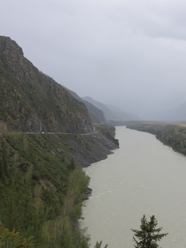
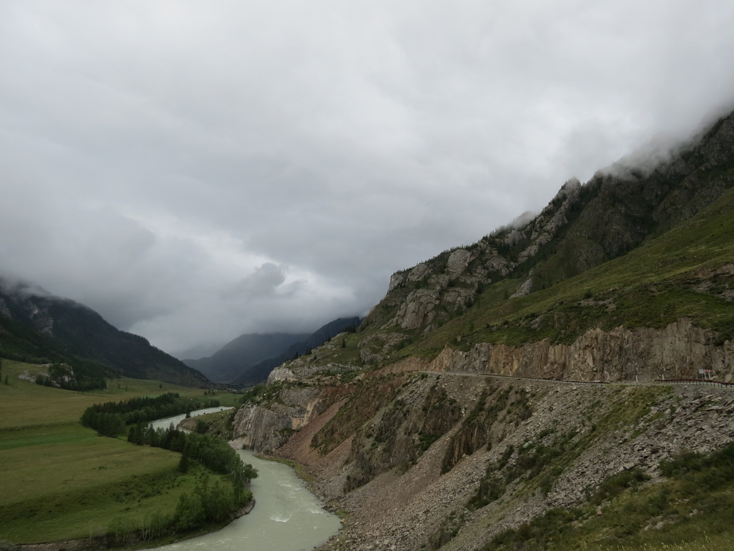
At sunrise we were on the road again and heading into the Altai Mountains. The road we were driving was a stunning road that clung to the side of mountains as roaring rivers flowed beneath us in deep valleys. In the brief interludes when the pouring rain stopped, the low-hanging clouds enshrined everything in mist and gave an eerie quality to the beauty we were witnessing. We discovered later this afternoon that the road we had driven was supposed to be the nicest drive in Siberia according to Lonely Planet, and I believe it! By early afternoon we had reached the border to exit Russia, and we were all ecstatic. For weeks Mongolia had been a theoretical concept; sure, it was always our goal, but it was also so far away. All of a sudden we were knocking on Mongolia’s door, and the years of dreaming and months of planning had actually paid off! Now we just had to get let in. While we were waiting in line in Russia we met Team Detour, a Swedish team in a snazzy new Škoda, and they decided they’d stick with us through the border crossing as well. It only took us two hours to get out of Russia, and with no idea what to expect we pulled out of Customs Control. As we were pulling out Charla asked Chase at what point he thought the paved road would end; before he could even answer, we realized that the pavement literally stopped at Russia’s legal edge. Welcome to Mongolia! After we spent many hours waiting for Mongolia to process our paperwork, all four teams legally entered the country at around 8PM. We had no intention of driving in the dark, so we drove about five kilometers away from the border and set up a massive camp on the side of the road. That night we cooked a giant camp stove feast and passed around a few bottles to celebrate that we had made it! Although we definitely knew that the hardest part of the trip was yet to come… Starting Point: N51°40 E85°46
Ending Point: N49°29 E89°43 Distance Traveled: 328.4 miles
0 Comments
Though there were eleven different Rally teams all staying at our same hostel, we finally did make it out of Almaty this morning! Our route took us north and east out of the city around Lake Kaphchagay and further on into the rolling hills of the Kazakh steppe. Unlike our adventures in western Kazakhstan, there weren’t any camel sightings here; instead of driving through sandy desert, we were gaining elevation and passing through very green and lush landscapes. When we weren’t busy admiring the scenery, we were playing leapfrog with an expedition motorcycle that had a license plate in Arabic; after a couple passes we all pulled over to talk, and we had the pleasure of meeting Johan, a South African who was riding a giant loop through Asia on a Bahraini-registered motorcycle. (We have a hard enough time using paperwork in English to get through borders using Cyrillic alphabets, and we couldn’t even imagine using paperwork in Arabic!) Johan had great tales and interesting plans, and we all decided to rendezvous later on in Ulaanbataar. After stopping at a cute little market in a small town, we found ourselves looking for a place to bed down for the evening. We pulled off the road onto a herding path, and set up camp beside the path a little way off the road. That night we were treated to one of nature’s finest shows! As we sat under stars enjoying dinner we had the pleasure of watching a captivating meteor shower overhead. The meteor shower ended when clouds rolled in, but the clouds kept the show going by hosting a lightning storm on the horizon that kept us company as we started to doze off. Starting Point: N43°13 E76°56
Ending Point: N46°04 E80°46 Distance Traveled: 347.1 miles We woke up with a plan to head a little further south to Vama Veche, a hippie beach town we had heard good things about from Rally Veterans (the beach party used to be there) and from current Ralliers who had somehow already stopped there. With itchy feet to be on the road again, we talked to the Long Time No Sea girls and decided to go north for what we thought would be an easy day trip to Odessa. We couldn’t have been more wrong, but we’ll get to that later… The day started out wonderfully. Charla made her scrambled eggs, and we packed up camp. We left Oha Beach and drove through scenic coastal Romania. Reaching the town with thought would lead into a National Park and a border crossing into the Ukraine, we realized the crossing was impassable by car with the help of a kind couple in a Lidl parking lot. So, we headed to Galati for the nearest border crossing, after discovering the boat at Isaccea was just for commercial purposes and then taking a different boat across the Danube and into Galati—this just after the “highway” dead-ended into a ferry terminal. Getting on the ferry was an orderly, timely affair. You could tell the ferrymen had arranged cars on a boat a time or two. Getting off the ferry was every-man-for-himself with every car driving quickly to get through the small space and onto the dock. We’re surprised we didn’t get separated from the girls then. There had been no street signs to indicate major highways in Bucharest, so why did we hope to see them here? We passed Around the World by Trike as we entered downtown Galati, and seeing both team members throw up their arms in a “Where the hell are we?” gesture was not inspiring, neither was the fact that we couldn’t physically get across enough lanes of traffic to talk to them about the journey. We made two stops in town—one at a nice hotel and one at a duty free shop on the Danube—and received contradicting directions. Somehow, we made sense of them and got onto the road out of the city, which soon led us out of the country. Getting out of Romania was a breeze for our EU pals, but we had to wait about an hour. The funny thing about waiting an hour at the Romanian border was that we had no idea whether we were going into Moldova or the Ukraine based on the maps we had, in which the three countries converge at one point. Then we had to wait another half an hour to get into Moldova. The two miles we drove in Moldova were quite nice. Then, the real adventure began. We’re not sure we even have words to describe the Moldovan-Ukrainian border. Our first indications were talking to Ralliers already at the border that had been there for between two to thirty hours. We certainly did not want to fall into the latter group’s case. In the three hours we were at the border, we managed to have the car fully searched, sign legal documents under duress without knowing what they said, nearly go to prison, and run out of cash. We finally crossed much too late in the night and found the girls anxiously awaiting us a few miles away. They had talked to another Rally team for part of the time we were stuck at the border and were hoping to meet up with them. In the dark, a wrong turn led us off into the middle of nowhere, so Pandaland stopped and cooled it for a couple hours. Today’s lesson: If you hear it’s an “easy day trip”—whether from fellow Ralliers or Google Maps—it’s not. Prepare for hell. Starting Point: N44°16 E28°37
Ending Point: N45°35 E28°35 Distance Traveled: 453.3 miles We started our day with a strangely simple but elaborate breakfast at the Pensiunea Minerva in Halmagel, Romania. We knew we had a lot of miles to cover to reach the beach party, and after missing the Pit Stop Party in Sibiu, there was no way we would miss the beach party! We hit the road after breakfast, and with the road conditions in that part of Romania, pieces of the Pandas were hitting the road as well. Thankfully, the road conditions improved as we approached Deva and stayed fairly nice all the way through Sibiu, including a section of brand-new highway that did not last too long because the road itself was under construction. From Sibiu, we found our way to the start of the legendary Transfagarasan, picking up a couple other Rally cars before stopping at the end of the straight stretch of road leading to the mountains (where a kind old lady came out to greet us with apples and her tiny fluffly dog). Now, as we head into the mountains, we should clarify: the Transfagarasan is no ordinary highway. The Transfagarasan is a strip of windy asphalt directly up and over the Fagarasan mountains, and it attracts drivers from all over the world; Jeremy Clarksson, the world-famous driver from Top Gear called the Transfagarasan “the most beautiful road in the world” after his team conquered it in Ferraris and Aston Martins. If it was good enough for Jeremy Clarksson, the road was definitely good enough for us, even though we were driving a different Italian car that starts with an F. By the time we started gaining elevation, our convoy had grown to five small cars struggling with the slope. We slowly creeped uphill, continuously switchbacking and crawling up, and occasionally stopped for photos as the Romanian farmland shrank from sight and opened up magnificent views. Towards the top of the Transfagarasan, the switchbacks practically double-back on themselves, searching for any route that can continue up, and creating a route so insane that our road map actually gave up trying to trace its course. After kilometers and kilometers of steep grades and blind corners we finally made it to the peak, and we could look down at the road we had just climbed. It was a glorious sight: in the foreground, a ribbon of asphalt that so tangled that it could tie itself in a knot, and in the background farmland stretching to the horizon. By now our convoy had grown to eight teams, and there were many hugs and high fives with photos being taken of various countries’ flags being held proudly in the wind. Not to be outdone, the trip down was spectacular as well. Shortly after the surprise herd of wild horses on a blind downhill corner, our brakes began overheating. Before a crisis could actually strike, we found a pull-off to cool off our brakes and allow the entire convoy time for sandwiches and snacks. After a while of enjoying the sunshine on the mountainside, it was time to head off. Not surprisingly, the trip down the mountain was much faster than the trip up, and before long we were back on the highway driving towards Bucharest. Driving through Bucharest was quite the adventure, though of a completely different sort than the Transfagarasan. Charla nearly had a heart attack navigating, as there were no road signs to be found. She remembered talking to a Romanian guy in Halmagel, and we made a right turn after the President’s House in the center of the city that led us along the canal to exit the city on the correct road. Spotting a couple other Mongol Rally cars out in the distance was fairly helpful too! Once we made it on to the highway, the frequency of Rally car-spotting increased. We were indeed headed the right way! Once in Mamaia, our convoy was cut off by a Rally car using us for directions; we had made it over a thousand miles together and got separated five miles from the party. We went straight to the beach and awaited the others. We celebrated our success with a beach party with the other Ralliers! Starting Point: N46°16 E22°36
Ending Point: N44°16 E 28°37 Distance Traveled: 474.9 miles There are late starts, and then there are late starts in Poland. We woke up in the hostel in Krakow, had a bit of the continental breakfast left out for our group, and recounted the events of the night before (some of which you can find on the previous post here, some of which are Pandaland jokes that don’t belong on here). Then, we went out to see some of the sights of the city that we had only glimpsed the night before, including walking around the main square and market. After a brief daylight tour of the city, we headed south to the Wieliczka Salt Mine, one of the twelve original UNESCO World Heritage sites. Before and after lunch in the café there, Andrew finangled us press entry with a private tour guide. The tour took us through three levels and down to 150 meters below the surface. Our favorite rooms were St. Kinga’s Chapel and the underground pool where we tossed in a coin with a prayer to get us to Mongolia. We also licked salt straight off the walls! Our tour guide even gave us lumps of rock salt to take on our travels; we won’t run out of salt for a long time now. We left Wieliczka but didn’t make it too far that night, choosing to camp in Nowy Sacz (a small town near the Slovak border) after a few shopping stops. We were the lead car, using paper maps to navigate after some mix-ups with the SatNav (GPS), and so we were happy to find a great spot for us all to stop for the night and make a big dinner. Starting Point: N50°06 E19°93
Ending Point: N49°37 E20°42 Distance Traveled: 70.4 miles For some reason late nights seem to be followed by early mornings, and we got up in time to see the massive Klenová Castle campground strewn with tents, sleeping bodies, and Rally cars everywhere. Breakfast was lacking, the toilets were in poor shape, and the drinking water tanks had run dry; but that’s what happens when the Adventurists invade the ruins of a castle that was built in 1291. While walking around Chase wandered into the camp of the PhilieasFog Reformers, and was quickly reminded that Charla had committed us to going to Poland today. Poland? Well, OK then, Poland it is. About five minutes before departure, the Long Time No Sea girls decided that Poland sounded fun too, and they jumped in their car to convoy. After a day of driving, and a day of GPS giving faulty directions to the lead car, we finally all rolled into Krakow hungry and cranky. After checking into Hostel Barok, it was time to tackle the city. Andrew, one of PhileasFog’s team members was Polish, and he was a great tour guide and translator for the entire group. We went straight to Krakow’s Main Square, the largest medieval town square in Europe, for a delicious dinner. The night started out very relaxed, but Andrew decided that since we were in Poland we needed a traditional Polish evening, so we headed to Do Zjedzenia. Do Zjedzenia is a bar that calls out to Krakow’s past; it’s more commonly just called The Communist Bar. The walls are covered in old newspapers, they have more vodkas than one can imagine, the bartenders are stern and slow-moving old women, and everything costs €1. We were having too much fun at the Communist bar, and we were shushed numerous times, but it was still a great night. Starting Point: N49°19 E13°13
Ending Point: N50°06 E19°93 Distance Traveled: 449.5 miles We woke up early, thanks in part to the sounds of the road nearby and to Jared and Duncan for shaking our tent. Getting up early put us on the road in the soft light of the morning, and we were able to enjoy the landscape a bit more than the night before when we were trying to find a camping spot. We didn’t drive too long though, as we were nearing the border of Luxembourg and wanted authentic Belgian waffles for breakfast. (Who’s heard of Luxembourgian waffles?) We found Café Melba in the main square of Bastogne, the perfect answer to our waffle desires. Though Chase liked his double waffle with fresh cream, Charla, Duncan, and Jared clearly chose the best option of a cappuccino and a waffle with fresh cream and fresh fruit. In Bastogne, we were just a few miles from Luxembourg, so our first international border crossing of the day was an easy one. Getting out of Luxembourg, however, proved to be much more of a challenge. The route we planned was simple—cutting across northern Luxembourg and then into Germany—but part of that road was closed. And, so was every other road we attempted to take to get back on that road. Two hours later, we found the German border, got on the autobahn, and headed east. Somewhere in the process of getting on the autobahn, we lost the kiwis (they made it to the castle two hours before us…). Again, a simple route proved to be the most difficult. An accident 5-10 kilometers ahead of us shut down the entire six-lane highway. We sat, and we inched forward. As the inching slowed, another Rally car approached! That’s how we met the Phileasfog Reformers! There’s not exactly tons of entertainment sitting on a major highway on a hot day. We listened to the stories of the man trying to get home for his own birthday party with his girlfriend (she was not a happy camper/didn’t believe he was stuck in traffic). We attempted to get the van full of British lads to come hang out with us. Then, Justin busted out a deck of Uno cards. We had to move the car forward a couple times, which helped us to finally discover a use for our cassette tape deck! It’s a perfect Uno cardholder! Then, just as the birthday boy told us would happen, the highway started moving again around 4:00 PM, two hours after we stopped. Once the autobahn opened, it was a straight shot for us to the Czech border and on closer to the party. We turned off the highway for a possible shortcut, though we’re starting to learn that perhaps the long way is the faster one. We drove through the scenic villages of Stod and Merklin before finding ourselves a little lost under a canopy road. Luckily, there was a Czech couple out for their evening walk. They looked at our map and discussed something, then started giving directions, of which we caught the words “Oplot” and “Presice.” With a flourish, he ultimately declared in English “LEFT!” Now, we didn’t take a left turn at all, but we were able to navigate back to the main road and on to Klatovy using his directions. Once in Klatovy, we realized the castle wasn’t actually located in the city. A giant map board helped us out after a bit of driving around. Stoked to know where we were going, we headed back through the city and noticed four Rally cars whirling around a roundabout. We jumped in with them, and after a pow wow with our friends of Ulaanbat-Tartan, took the lead to Klenova Castle. With the last flecks of daylight illuminating our drive, we led the caravan into the castle! A feast and party were waiting. Today’s lesson: A journey of a thousand miles always starts with someone saying, “Hey, I know a shortcut.” Starting Point: N50°10 E05°22
Ending Point: N49°19 E13°13 Distance Traveled: 513.9 miles After spending so much time so close to Slovenia, we decided we just had to make the trip there; however, not knowing what to expect, we thought we’d just take a bus and spend a couple hours in the local seaside town of Koper. From the bus station we took some time to wander through the old historic city and to check out the sea. Unfortunately, Koper is a small town with not that much happening, so our explorations didn’t take up the full couple hours we had allotted until our bus back to Trieste. Luckily, we found a local pub that was selling Laškos, our favorite Slovenian beer, and we decided to try the non-export version. Much as we expected, it was fantastic! Plus, Okrepcevalnica pr Bepca had by far the cheapest beer in Europe at €2.50 for a half-liter! Once we were back in Italy, we celebrated our last Italian meal appropriately by devouring amazing pizza!
For breakfast today we went to one of last night’s last stops, and we started our day at Eldur & Is with some delicious breakfast crêpes with our Alaskan friends. As they were figuring out their plans for the day, we went off to the National Museum of Iceland. To our delight, the museum was hosting an exhibit by famous Icelandic photographer Sigfús Eymundsson, who neither of us had ever heard of before. His photographs of Iceland in the late 1800s and early 1900s were quite similar to photographs of Alaska of the same time period, and elicited the same feelings of cold and isolation at northern latitudes; needless to say, Chase loved them. In addition to that exhibit, it was a really well-organized museum: it told the entire story of the history of Iceland starting from The Settlement in 871 AD and coming to Y2K. We definitely enjoyed the museum, and now know a lot more Iceland’s history. After the museum, we stopped by 1011 (an Icelandic convenience store) to purchase our supplies for a picnic lunch. The Hljómskálagarðurinn neighborhood of Reykjavík was beautiful in the sunshine, and we ate after strolling around Tjörnin Lake. Later that evening, we finally were able to take part in a signature Icelandic tradition: geothermal hot spring pools! But instead of going out to a beautiful, remote location, we went for the true Reykjavíkian experience of taking a dip in the Laugardalslaug Public Pool in the city. The public pool consisted of a collection of hot tubs of varying water temperatures, a children’s area, and a lap pool. We packed into the hot tubs with all the rest of Reykjavík who were relaxing after a day’s work. With an air temperature of 8oC and water temperature of 40oC, it was a very refreshing experience.
From there we took a scenic walk along the water back to the hostel, where we made a late dinner before going out to Ölsmiðjan Café-Bar (a.k.a. Polar Bar and Home Bar) for a last Polar Beer. With the sun out all the time, like in Alaska, we didn’t even realize we were well into the night by dinner time. The early morning hours approached, and so we called it a night just a little too late to sample the pylsur hot dogs or kleina donuts on the walk back to the hostel. I guess we’ll just have to go back to Iceland one day… At the bright and early hour of 6AM local time, we got our first glimpses of Iceland as our flight descended into Keflavik. An hour later our bus was dropping us off on Laugavegur, a nice area of Reykavik, where we found our hostel. After getting set up for the night at Reykjavik Backpackers, we started wandering around town. The first thing we found was the biggest landmark in the city, Hallgrímskirkja Church. The church is the tallest building in the city with a gigantic interior space, as well as a giant organ with over 5,000 pipes! We also wandered down to the harbor where we found the new Harpa performing arts center. Saving the best for last of our morning wander, we explored the Iceland Phallological Museum. Yes, you read that right: we found possibly the world's only penis museum! All our wandering made us hungry, and at that point eating Iceland's signature hot dog wasn't a great idea! One of the only affordable dining options in Rejkavik is the ever-present noodle house, and we found a great option at Noodle Station near our hostel. Maybe it was the noodle soup, the grey skies, or we thought it might be the jetlag, but after lunch we passed out and slept the afternoon away.
Luckily, we awoke in time for Alaskan adventures! We met up with our friend Laura and her friend Caleb, both from Anchorage, in the bar below our hostel for our first taste of Icelandic beer! Unfortunately, Viking beer really doesn't live up to its name. Always the frugal travelers, we soon moved to Micro Bar in time for happy hour and found a tasty beverage: Gæðingur! Now that is a beer worthy of the Vikings! Laura and Caleb had been in Iceland for a couple weeks, so after a dinner of noodles, their local knowledge brought us to Ölsmiðjan Café-Bar for one last Polar Beer to end the night. Between the recent half-marathon, a late night in Alaska, and the time zones, we slept like babies on our first night in Iceland! |